Sunday, September 13, 2015

Covered Bridges of New Hampshire

We took a day trip to see some of the covered bridges in the White Mountains area.  After picking up a map in the campground office that listed each of the bridges and showed where each one was located, we started our drive through the countryside and mountains checking off the bridges as we came to them.  You could drive through most of the bridges, however, there were a few that you could only walk across.  There was also one that had a gift shop in it.  Some were from the late 1800's while a few were from the 1990's and even as new as the 2000's.

Below are pictures of a few of the covered bridges that we saw. 


Lancaster covered bridge dated 1862.


The Swiftwater bridge dated 1849.


 One lane only....all wooden. 


Jackson bridge dated 1939.


The Jackson bridge was one of the more scenic bridges.


Inside this bridge.....


Covered bridge at Bath, NH dated 1832.


After we left the White Mountains we headed just a few miles south to the Lakes Region of New Hampshire. 


Tuesday, September 1, 2015

White Mountains of New Hampshire


We didn't have far to travel to get to the next campground, but it was slow going through the mountains.  We went through the White Mountain National Forest to an area called Twin Mountains city of Carroll, New Hampshire.  It is conveniently located for taking day trips to visit some of the many covered bridges throughout northern New Hampshire and Vermont......and most importantly, still in the mountains so we can enjoy the cooler weather.


We began to see these beautiful white birch trees which are the official  state tree for New Hampshire.


All throughout the northeast into Maine and even Nova Scotia, we would see piles of firewood in peoples yards ready for the upcoming winter season.  Also, more of those beautiful white Hydrangea bushes!


 We were somewhat surprised to see this pickup truck in New Hampshire flying his rebel flag.....


As we got closer to the campground, we saw a warning sign for moose in the area........who knows, I may get another chance for a picture. :)


But first.........we decided to ride the Cog Railway to the top of Mt. Washington located only 20 minutes from the campground. 
 
 
 Mt. Washington Cog Railway
 
The Mt. Washington Cog Railway is the world's first mountain-climbing cog railway (rack and pinion railway).  It uses a Marsh rack system and one or two steam locomotives and five biodiesel powered locomotives to carry us tourists to the top of the mountain.  It is the second steepest rack railway in the world with an average grade of over 25% and a maximum of 37%.  The train goes up the mountain at an astounding 2.8 MPH.  Like the Brakeman on our train said....." we are off like a herd of turtles"!  It descends a little faster at 4.6 MPG.  It takes approximately 65 minutes going up and 40 minutes going down. The train depot is located at 2,700 feet above sea level, while the summit of Mt. Washington is 6,288 feet.


Located in the museum is an example of how the cog works.
Below is a picture of the cog (or rack and pinion) system that allows the locomotive to climb Mt. Washington. The rack rail design uses a ladder-like rack with open bar rungs engaged by the teeth of the cog wheel.  This system allows snow and debris to fall through the rack rather than lodge in it. 


Also located in the museum was a picture of the "Devil's shingles" 
(pictured  below). 
 Back in the early days during the railway construction, men used these simple home made devices to descend the mountain at 60 mph!  The slideboards as they were called fit over the cog rack and had enough room for a worker and his tools.  The "Devil's shingles" were banned in 1906 after the accidental death of an employee. 


 We took this picture of the steam powered engine as it was coming back from the top. 


The passengers on board disembarked and another group boarded.....then up they went!  The steam powered train only goes up twice a day and are booked in advance.  We rode on one of the biodiesel trains.  Which was okay, because we got to watch this magnificent sight going up the mountain!


After giving the steam powered engine a little head start up the mountain, we boarded our train and headed up the mountain behind it.


As we got higher up the mountain, the brakeman pointed out the trees growing along the tracks were actually growing straight up.....it was us that was on such an angle.


We passed a stone face that was clearly visible with the white backdrop behind it.  From this picture you can also see the track as it works its way up the mountain.


Our view looking out over the mountains.


You can really tell how steep we were in the picture below.  I stuck my arm out the window and took a picture back down the mountain.


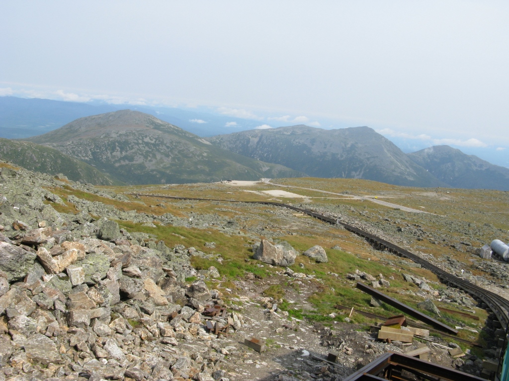
We are now above the tree line.......only a lot of rocks.


Finally made it to the top!


Our train goes back down to pick up more passengers while we have approximately an hour to look around and take pictures.


We learned on the way back down that the engine and the train car are NOT connected in any way.  On the way up the engine pushes us and on the way down it keeps us traveling down the mountain at a steady pace .........or in other words, from  careening out of control! 
 
 
At the summit you can stroll onto the observation deck to enjoy panoramic views, visit the 1853 Tip Top House, and then on to the Visitor Center which houses a weather museum, snack bar and, of course, a gift shop.  There is also a post office located at the summit where you can purchase a post card and get a unique Mt. Washington postmark. 
 
The Tip Top House located at the summit is a historic former hotel.  It is the oldest surviving building on the summit.  It currently features exhibits concerning the mountains history. 


It was windy and cool at the top!


Below is a picture of some of the weather equipment.


The mountain boasts some of the planet's worst weather.  Mt. Washington's summit is where the world's highest speed observed by man was recorded.  It has also been recorded to have had an astounding minus 40 degree temperature and hurricane force winds in the winter and has never been over 74 degrees in the summer.  When we got to the top is was somewhere in the upper 40's.


The pictures below were taken from the observation deck looking down the mountain where our car is parked.....somewhere down there!


We were above some of the clouds.  It was yet another great weather day......plenty of sun and warmer at the bottom.


Alan was checking out the rail system....it just drops down out of sight!


Another train just arriving.....


We have boarded our train and headed down.  You can see how steep it is by looking down the tracks.


This was another train as it was headed back down the mountain.  That almost looks like snow on the mountain, but it is rock.


This is one of the hiking trails leading up to the summit.  Mt. Washington is one of the most popular hiking, backcountry skiing, alpine climbing and ice climbing destinations in New England, affectionately known as "the rock pile".


Below are a few of the hikers making the trek back down.
 
 
Had a great time on the Cog Train!
 

Sunday, August 30, 2015

Back in the USA!


Bangor and Portland, ME.....revisited!

We left PEI in the morning and drove to Bangor, ME.  We were going to be there for a couple of days, so we decided to drive down to the Acadia National Park on Mount Desert Island.  Bar Harbor is located on the island, however, since we had visited Bar Harbor during our 2008 trip to Maine, we decided not to drive into town.  Instead we drove through the Acadia National Park up to the top of Cadillac Mountain.  It is the highest point on the island.  When we were there in 2008, it was a clear day and you could see for miles.  This time we were in the clouds/fog/mist.....you could hardly see the road.  As soon as you came off the mountain, it was clear.
We left the park and drove back toward Trenton where Alan had another LOBSTAH! 

The lobster pots are right out in the parking lot.  Once you go inside and order your lobster, they have you pick out the one you want.  they put it in a large mesh back and take it out to the pot..........


.......we all know what happens then.
He said they keep getting better and better!


 From Bangor we went back to Scarborough, ME, (just outside Portland)which is the same area we stayed in going up.  Our generator in the motorhome needed some attention and there was a Cummins dealer in that area that could check it out for us.  We ended up staying one night in their parking lot while they waited for a part to come in.  We called it "Camp Cummins".  They are used to having people overnight there.....they even have an electrical outlet behind their building for motorhomes to plug into for 50 amp service. 

While we were there, we decided to ride back to Old Orchard Beach and walk down to the Pier since we didn't get to see that much on our first visit.
We got to the Pier and beach area early this time, however, nothing opened until 11 am, so we just hung around until then.  You can see from the picture below how empty the beach looks compared to the next picture taken about an hour later.


Around 10:00 A.M.


Around 11:00 A.M.


Below is a picture of the Pier (shops and restaurants) looking towards the Atlantic Ocean.


This is entrance to the "The Pier".  There are also shops and restaurants located on the outside of the pier and for several blocks from the pier.


As we walked down the pier, you can see the many Tee shirt shops and food vendors.  The building on the very end was a large restaurant.


 After more Fish and Chips for me and a Lobstah roll for Alan, we headed back to Camp Cummins.  :)
 
True to their word, the part came in the next morning and everything was working fine by noon.  We headed for the White Mountains of New Hampshire in hopes of finding cooler weather!
 

Prince Edward Island, Canada


The bridge that connects New Brunswick and Nova Scotia to Prince Edward Island is called the Confederation Bridge.  It is 8 miles long and sits high above the water.  It is a toll bridge, however, you only pay the toll when you leave the island.  If you came by car and left the island by airplane or boat, you would not have to  pay the bridge toll. 


The toll for a  2 axle vehicle (car, pick-up truck, RV, etc.) is $45.50.  Plus $7.50 is charged for each additional axle.  Our toll for the RV plus towing our car ended up being $60.50.  They let you know well ahead of time in case you don't want to pay all those $ to get off the island!


The view as you approach the bridge.


Yep!  Put away those cell phones on this bridge.  I wouldn't want to meet a distracted driver crossing this!


Another hump near the end of the bridge.  It's taller than it looks. 


Prince Edward Island Coastal Scenic Drives

PEI scenic drives are divided into three sections.  The scenic drive for the central part of the island is called "Red Sands Shores" on the south end and "Green Gables Shore" on the north end,  Points East Coastal Drive on the eastern side of the island, and the North Cape Coastal Drive on the western side.  We spent three days driving all three of the scenic drives.


It was foggy the first morning we set out for the central drive, but we were able to take the picture below of the many, many potato farms. 


The fields of  bright yellow flowers turned out to be Canola fields.  Canola oil is made at a processing facility by slightly heating and then crushing the seed and then refined into edible oil. 
 

As we continued around the bottom coast of the central section , we began to see more large farm houses and farmland.  We were truly amazed at the vast amount of farmland in the central and eastern parts of the island.  PEI is famous for it's potatoes.  Below are a few of the farms we saw along the way.


 Most of the farms were potato farms, however, some were dairy farms and some were hay or wheat.


And large farm equipment to go with it....


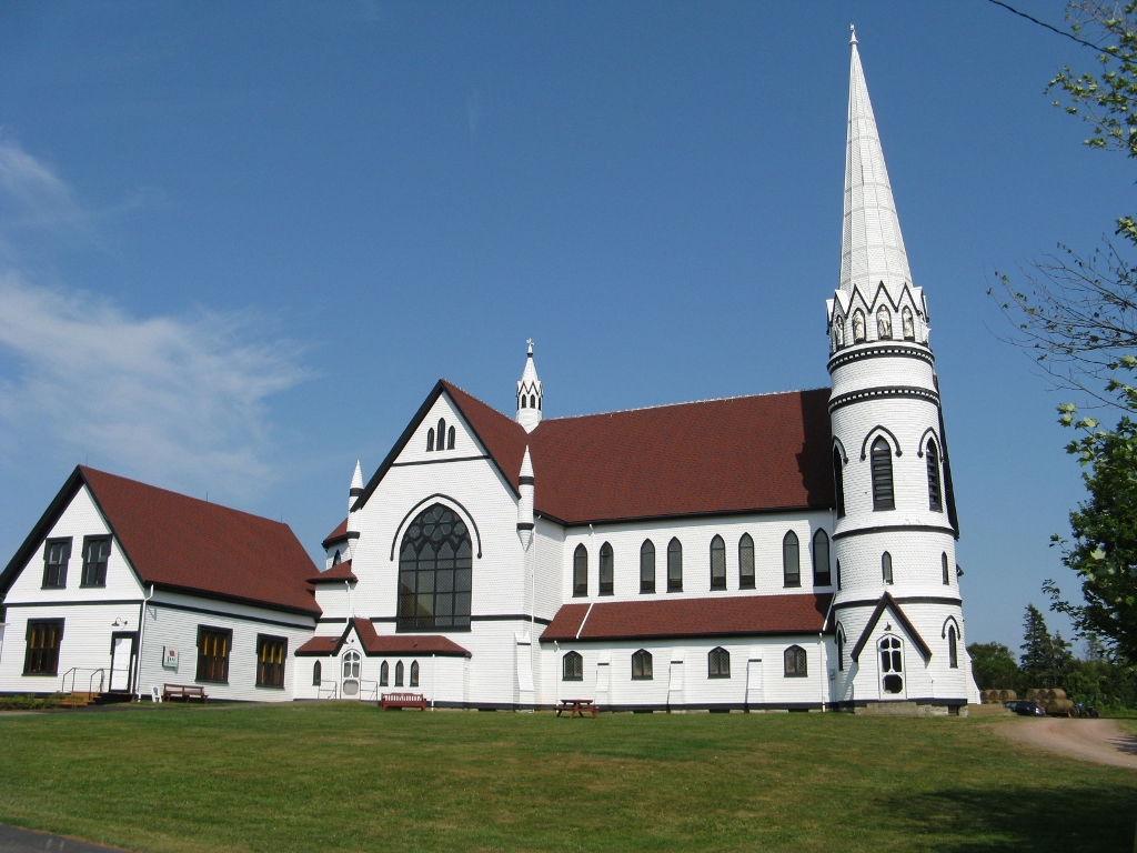
As we drove around, we kept seeing these beautiful churches.  We saw a lot more than I took pictures of, but here are a few of them taken during our visit on the island.


The details on some of the churches were extraordinary!


Some of the older churches had a cemeteries completely surrounding the church.


The houses were very decorative as well.  Lots of gingerbread trim on houses in most neighborhoods throughout PEI.


We stopped at several lighthouses along the way.  I have posted a few that we saw along the way.
 
This lighthouse is on the PEI side of the Confederation Bridge.  You can barely make out the bridge in the picture due to the fog  on this particular morning.


There are more than 50 of these structures dotting the ragged coastline.  More than 38 still function as navigational aids, and nine are open to the public.  We were only able to visit a few of the many lighthouses. 


Charlottetown is both the largest city on and the provincial capital of PEI, and the capital seat of Queens County.  On our way toward Charlottetown, we stopped at the historic, Port-la-Joye - Fort Amherst to view the harbor across the way.
 
Originally established by the French in 1720, Port-la-Joye - Fort Amherst commemorates the first permanent settlement on Ile Saint-Jean (today Prince Edward Island).  The forts grassy ruins are still visible, and interpretive panels explore its rich history.  The grounds also offer superb views of Charlottetown Harbour.


Charlottetown, PEI
 
Charlottetown Harbour in the distance.  Cruise ship was in port that day.


We drove into downtown and the port.  As with any tourist port town, there were many people and many cars.  We had planned to eat lunch there, but with no place to park and too many people (the cruise ship had unloaded for the day) we decided to move on.  We did end up in Charlottetown later in the week for dinner.


I think the best part of the scenic drives for me were the little fishing villages and working harbours.  There were many! 


The structures in the background are used by the fisherman/lobstermen to house their supplies.  Many of them were full to the brim with lobster traps.
We were told that the lobster season begins and ends at different times depending on the area. 


As we drove to the upper part of the central island, known as the "Green Gables Shore", we started seeing information about "Anne of Green Gables", which is a 1908 novel by Canadian author, Lucy Maud Montgomery.  It was written for all ages, but has been considered a children's novel since the mid-twentieth century.  It recounts the adventures of Anne Shirley, an 11 year old orphan girl who is mistakenly sent to Matthew and Marilla Cuthbert, a middle-aged brother and sister who had intended to adopt a boy to help them on their farm in Prince Edward Island.  The novel recounts how Anne makes her way with the Cuthberts, in school and within town. 
Anne of Green Gables has sold more than 50 million copies and has been translated into 20 languages.  It has been adapted as film, made-for-television movies, and animated and live-action television series.  Plays and musicals have been created.   The Confederation Centre of the Arts in Charlottetown has featured the wildly successful Anne of Green Gables musical for the past 50 years.
 
The Green Gables farmhouse, which is the setting for the book, is located in Cavendish, PEI.  This has become a very popular area as those who love the books or the mini-series make their way to Green Gables Shore in pilgrimage-like fashion to visit the sites that pay tribute to their favorite red-haired heroine and her creator, Lucy Maud Montgomery.  It is operated by the Parks system.


We had many miles yet to travel that day, so we only were able to drive by the entrance.
 
Further down the road we saw the house where the author was born.
 
 
My curiosity is peaked.....I will now have to read the book. 


We really enjoyed the scenery and history on the Central Coastal Drive.  We stopped all along the way to see the harbours and take pictures.  Many of the boat pictures were taken for me to paint later.
 
Below is the French River Harbour.   There was a marker posted at the site where we stopped to take pictures of this area that read..."Where Farm meets Tide".   It is one of PEI's most picturesque fishing villages.


Points East Coastal Drive
 
We started out the next morning to drive the Points East Coastal Drive.  There is a lot more coastline on this drive, therefore, there were a lot of harbours and lighthouses to see!
 
 
These white Hydrangea bushes were in full bloom everywhere, as well as a tree that looked just like the bush. 


Shed full of lobstah pots!
 

Dinghy's with wheels....


Another little fishing village and harbor.....
 
 
This one had a narrow wooden bridge you had to cross.


More miscellaneous pictures.


We thought this guy was collecting his mail, however, as we passed him, we realized that it was not really a man, but instead it was a mailbox stand.  It looked so real!  We had to go back for this photo.


I just loved these small boats......!


The North Cape Coastal Scenic Drive
 
 
Our last excursion on the island was the North Cape Coastal Drive.  I think I had mentioned earlier that PEI is famous for it's potatoes.  We had heard about the Canadian Potato Museum that was along this drive so we had to stop and check it out.  They have a "country kitchen" at the museum where they make potato fudge, chocolate covered potato chips, and my favorite......fresh hot French fries!
 
It just happened to be lunchtime when we arrived at the museum, so we ordered our huge plate of fries and enjoyed them immensely!


As we drove on through the farmland, we began to see a lot of wind turbines.


The natural phenomena of North Cape - its age old patterns of winds and tides are what actually caused the formation of PEI's famed north shore beaches over the millennia.   
 
 
You see the presence of towering, churning turbines in this area and at the Wind Energy Institute. 
There were parts of the wind turbines on display at the institute.  I had Alan stand in front to give you an idea of just how big these machines are. 


Below is the blade....the round end of the blade goes in the round hole in the piece in the top picture. 


This was taken out in the country.  There was actually a "farm" of these turbines, but we took a close-up of just this one.


The Wind Energy Interpretive Center was also a visitor information center as well as a gift shop.


As we were driving back toward the campground, we spotted the Confederation Bridge in the distance.