Checking them off our list! ✅
Not long after we turned off the main highway, we traveled a short distance before we came across the Red Canyon in the Dixie National Forest. A rain shower had just passed, so the sun was not on these formations, so we got these pictures on our way back that later that day.
We drove through 2 short tunnels....back to back.
This park also has the free shuttle buses, but unlike Zion, it is not mandatory here. We decided to drive our own car through the park instead of the shuttle. Luckily we got there early and there seemed to be plenty of parking at all of the pull offs and viewing area parking lots/spaces.
Our first stop was at "Inspiration Point". We got out of the car and walked out to the viewing area and looked over the edge with our mouths open. I have never seen anything so astonishing and amazing! I know I keep saying it, but pictures don't do it justice. These were individual spires shooting straight up. They are called hoodoos. Some are as tall as a 10 story building.
This is just a zoomed up version of this area.
Just panning the camera around to the other side. You can see the clouds are still in the area.
We were getting higher. We started out at an elevation of about 8000 feet and will be working our way up to around 9000 feet.

We took a short walk out through this pine forest to see what was at Fairview point.
It gave you a broader view of some of the area from this vantage point.
The name given to the rock layer that forms hoodoos in Bryce Canyon is the Claron Formation. This layer has several rock types including siltstones and mudstones but is predominantly limestone. Thirty to forty million years ago the rock was "born" in an ancient lake that covered much of Western Utah. Mineral deposited within different rock types cause hoodoos to have different colors throughout their height.
The hoodoos are formed by two weathering processes that continuously work together in eroding the edges of the Paunsaugunt Plateau. The primary weathering force at Bryce Canyon is frost wedging. Here they experience over 200 freeze/thaw cycles each year. In the winter melting snow, in the form of water, seeps into the cracks and freezes at night. When water freezes it expands by almost 10 %, bit by bit prying open cracks, making them even wider in same way a pothole forms in a paved road.
The hoodoo in the center of this photo is called "Thor's Hammer". It is named after the one of the most important and famous gods in Norse mythology. Thor was considered the storm-weather god of sky and thunder. This hoodoo resembles the mythical hammer of the Norse god.
Where's the dirt? This tree seemed to be growing out of this rock.
This is called the "Natural Bridge" arch. It is breathtaking!
More gorgeous scenery!
This view area was called "Agua Canyon".
At every point of interest we stopped at on the way to the top, you saw a different view!
We were amazed when we stopped at the viewing area for the "Sunset Point Trail - Navajo Loop Trail". You could hike down to the bottom and way over to the side of these hoodoos. Believe me when I say it was a long way down there. I'm sure a lot of the hike was somewhat level the way the trail was cut into the side of them, but you know that you have to somehow climb back up to the top. In the picture below you can see people on the trail.....what you can't see are the trails along the sides and at the bottom.
We kept taking pictures because it was just amazing that you could actually walk down to the bottom.
Okay, I think you get the picture!
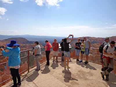
Everybody that wasn't down in the hoodoos was up here trying to take pictures.
It was getting later and the viewing areas were beginning to get busy. Tour buses, cars, and shuttles were going round and round this particular area waiting to park.
We found a nice shaded picnic area for our lunch. As you can see this was one area that wasn't very busy. It was cool the entire time we were in the park. In fact, early that morning, I had to put on a lightweight jacket. But by mid morning it was very pleasant and it stayed that way. We talked to a guy at one of the viewing areas that said he was here the day before in the afternoon and it rained for hours. It looked like it was starting to get cloudy as we were leaving.
Another great day in another beautiful National Park.
Our next destination is the Grand Canyon.


No comments:
Post a Comment